
The Invisible Network: Chapel Hill’s Hidden Transportation System
There is a dense fabric of natural surface trails woven through Chapel Hill and Carrboro, and you’ve likely used them when cutting through the woods behind a neighborhood or taking a dirt path to a school. What you probably didn’t know is that there are over 138 miles of these trails inside our towns’ limits and most of them don’t appear in any official transportation plan. They’re unmapped, unmaintained, and unprotected as transportation assets, not because they aren’t used, but because planning frameworks haven’t yet recognized them as infrastructure.
My master’s research at UNC Chapel Hill is about closing that gap, and the numbers make a convincing case. Our dedicated sidewalk and greenway network totals around 307 miles. Add natural surface trails and those 138 miles represent a 45% increase in walkable connections.
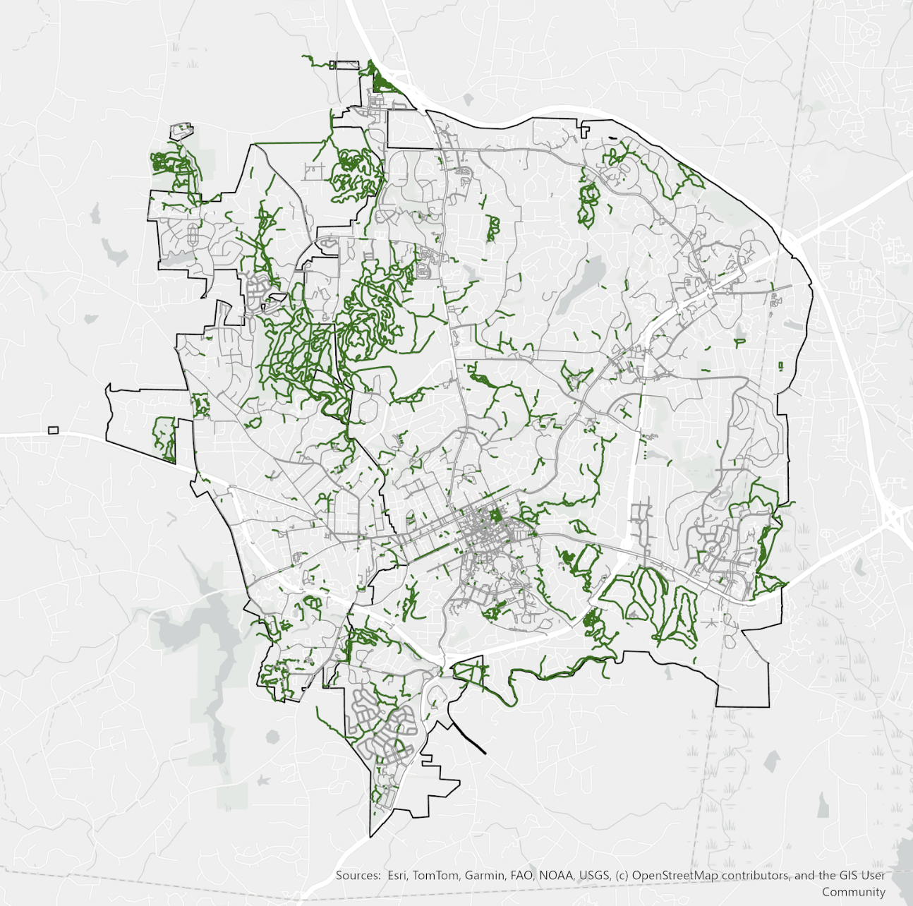
GIS map of the invisible network of trails in Chapel Hill and Carrboro
That missing mileage has consequences. My GIS-based network analysis used a ¾-mile walkshed around each school, a more conservative threshold than the district’s 1.5-mile busing cutoff. Even with a conservative approach, I found that more than 1,700 homes in Chapel Hill and Carrboro gain access to a public school in a sub-15 minute walk when natural surface trails are included in the transportation network, a 14% system-wide increase. Chapel Hill High School’s walkshed, where the wooded trail network provides the most low-stress walking connections for nearby neighborhoods, grew from 77 homes to 271: a 252% increase!
The research also draws on interviews with transportation planners and active transportation advocates in Chapel Hill, Carrboro, and Asheville. The institutional picture those conversations reveal is as important as the spatial analysis. Trails fall outside formal planning frameworks partly because of legitimate concerns about accessibility standards, maintenance liability, and departmental jurisdiction, and partly because they’ve simply always been categorized as recreation rather than transportation. Changing that requires working within those institutional constraints.
Asheville offers a useful model. Local trail advocates there didn’t wait for the city to act. They cataloged the network, built public support, and gave planners something to work with. The result was AVL Unpaved, adopted as part of the city’s 2022 Close the GAP plan, which formally incorporates natural surface trails into the transportation network using federal accessibility design standards and a clear framework for prioritizing projects. The lesson: start with projects on municipally owned land, build visible evidence, and tackle contested sites after the concept is proven.
Chapel Hill and Carrboro aren’t starting from scratch. The infrastructure already exists and people are already using it every day. What’s missing is the recognition that these trails are part of how our communities move. The research puts our local trail network on the map. If we follow where it leads, we can make the invisible visible.